

Published on: 08/20/2025

Description
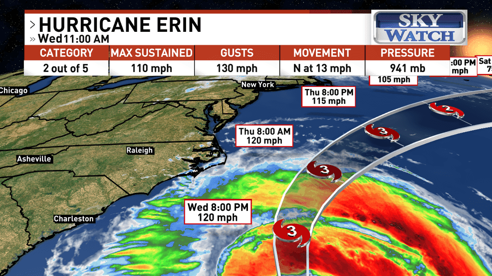
ASHEVILLE, N.C. (WLOS) — The eye of Hurricane Erin was located 365 miles SE of Hatteras, N.C., at 11 a.m. on Wednesday.
Maximum sustained winds have increased to near 110 mph with higher gusts. Some additional strengthening is likely during the next day or so, and Erin could become a major hurricane again by tonight.
Category 3 winds begin at 111 mph. Weakening is likely to begin by Friday, but Erin is forecast to remain a hurricane into the weekend.
Erin is moving toward the north at nearly 13 mph. A turn toward the north-northeast is expected later today and tonight, followed by a faster motion toward the northeast and east-northeast by Thursday and Friday.
On the forecast track, the center of Erin will move over the western Atlantic between the U.S. East Coast and Bermuda today through early Friday, and then pass south of Atlantic Canada Friday and Saturday.
SUMMARY OF WATCHES AND WARNINGS IN EFFECT:
- A Tropical Storm Warning has been issued from north of the North Carolina/Virginia border to Chincoteague, Virginia.
- A Tropical Storm Warning is in effect for... Beaufort Inlet, North Carolina, to Chincoteague, Virginia, including Pamlico and Albemarle sounds.
- A Storm Surge Warning is in effect for...Cape Lookout to Duck, North Carolina
- High Surf Advisory along the entire Carolina Coastlines into NE GA.
Other Related News

08/20/2025
WALB is working to produce a video for this story In the meantime we encourage you to watc...
08/20/2025
DECATUR COUNTY Ga WALB - A man was arrested in Decatur County after attempting to set the ...
08/20/2025
WALB is working to produce a video for this story In the meantime we encourage you to watc...
08/20/2025
GRADY COUNTY Ga WCTV - The Grady County Sheriffs Office announced Wednesday morning that d...

08/20/2025
TNND Rice University researchers are using artificial intelligence to superpower extreme ...
Follow

Download Our App


Copyright 2022 © Albany Metro Community. All Rights Reserved